During the night of March 12-13 1906, a very severe storm tide occurred along the German North Sea coast. It caused serious damages to coastal protection structures and resulted in extensive flooding of low-lying areas (Möller, 1906 and Bebber, 1906). Along the Lower Saxony coastline, the water levels observed during this event are still the highest on record for some tide gauges such as at Borkum or in Emden. For others such as at Norderney or in Wilhelmshaven, higher water levels were observed only during two more recent storms in 1962 and 2013 (Deutsches Gewässerkundliches Jahrbuch). Consequently, the water levels of the storm tide are still relevant for the design and specifications of coastal defence at parts of the Lower Saxony coastline. Despite its outstanding role for coastal protection, water levels during the 1906 event have not been comprehensively reconstructed due to limited data availability.
In a joint effort within the project EXTREMENESS (short for: Extreme North Sea storm surges and their consequences) the Institute of Coastal Research at the Helmholtz-Zentrum Hereon and the Deutsche Wetterdienst (DWD, German Meteorological Service) in Hamburg have now reconstructed and modeled air pressure, wind and water level fields during the 1906 storm tide event. For this, the so-far unexploited archive of logbooks from ships and station data available at the DWD from that time proved to be particularly valuable. For March 1906, weather data from this archive were digitized and plotted as weather maps. From these, an experienced meteorologist created twelve-hourly atmospheric pressure maps. Subsequently, these maps were also digitized and used to calculate the according two-dimensional geostrophic (physically consistent) wind fields. Then, near-surface marine wind speeds were derived from the geostrophic wind using a parameterization developed by Hasse (1974), and wind and pressure data were eventually used to force a hydrodynamic model of the North Sea to reconstruct the water levels during the historic 1906 storm tide by additionally taking the astronomic tides at this time into account.
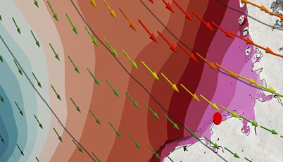
Video 1: With the isolines representing the sea level pressure, the visualization shows the passage of low-pressure systems. The wind direction and speed is depicted by the arrows and their color shading, and the water level for March 8-14 1906 is shown by the color shading of the sea surface. In addition, the development of the simulated water level for the tide gauge at Norderney is shown on the little plot on the right-hand side with and without the contribution from wind surge.
The storm tide in the night of March 12-13 1906 was exceptionally high and represented the peak event within a series of storm tides in March 1906. This series was created by several low-pressure systems that moved across the North Sea, some of which had strong northwesterly wind components leading to high surge levels in the German Bight. During the event of March 12-13, these high surge levels coincided with high astronomical spring tides, which in turn lead to the exceptionally high-water levels along the Lower Saxony coastline. According to criteria for present storm tide levels issued by the Lower Saxony Water Management, Coastal Defense and Nature Conservation Agency (NLWKN), the 1906 event represents a severe - and at some places even a very severe - event that is to be expected less than once every about 20 years.
Project Website: https://ms.hereon.de/extremeness/
Authors/Contact:
- Dr. Elke Meyer, Institute of Coastal Research at the Helmholtz-Zentrum Geesthacht, (Email: ZWxrZS5tZXllckBoZXJlb24uZGU=)
- Dr. Ralf Weisse, Institute of Coastal Research at the Helmholtz-Zentrum Geesthacht, (Email: cmFsZi53ZWlzc2VAaGVyZW9uLmRl)
Visualization:
DOI: https://doi.org/10.5446/49529
Publications:
Meyer, E. M. I., Weisse, R., Grabemann, I., Tinz, B., and Scholz, R.: Reconstruction of wind and surge of the 1906 storm tide at the German North Sea coast, Nat. Hazards Earth Syst. Sci., 22, 2419–2432, 2022. DOI: 10.5194/nhess-22-2419-2022
Bebber, W.J. van: Bemerkenswerte Stürme. Annalen der Hydrographie und Maritimen Meteorologie, Juni 1906, S. 290
Deutsches Gewässerkundliches Jahrbuch (DGJ), Landesamt für Landwirtschaft, Umwelt und ländliche Räume Schleswig-Holstein, Flintbek 2014, ISSN 2193-6374, dgj.de
Hasse, L.: Note on the Surface-to-Geostrophic Wind Relationship from Observations in the German Bight, Boundary-Layer Meteorology 6, 197 pp., 1974.
Möller, E.: Die Sturmflut vom 12./13. März 1906. In: Mitteilungen d. Nordfriesischen Vereins für Heimatkunde u. Heimatliebe. 1905/1906, Heft 3, S 112-119.