Why kilometer-scale climate simulations are exciting
Typical climate models, on whose results important statements of the IPCC Assessment Reports are based, today simulate the climate on grids with a horizontal resolution of about 100 kilometers for atmosphere, ocean and land. At these spatial scales, many processes that play a critical role in weather and climate cannot be represented directly using the physical equations of the models. The effects of these processes in each grid cell are therefore represented using assumptions called parameterizations. In doing so, the modeling uses the average effect of these small-scale processes as an approximation for the entire grid cell. The resulting inaccuracies are partly responsible for many uncertainties with which climate forecasts are still afflicted. Examples of such small-scale processes are eddies in the oceans, high reaching cumulonimbus clouds in the tropics, fine structures and especially cracks in sea ice. In the same way, however, small-scale geographic structures, such as the morphology (topography, bathymetry, land-sea distribution, islands and lakes) and texture (vegetation and built-up areas) of the Earth's surface cannot be adequately accounted for.
Kilometer-scale processes are exciting from many perspectives. Because more processes are computed based on physical descriptions rather than parameterizations in a direct simulation, the uncertainties introduced by these parameterizations no longer contribute to the uncertainties of the climate projections. For example, clouds and precipitation, and thus heavy rainfall events in the future, can be simulated directly rather than approximated with a statistical model. The climate scientists in effect simulate the weather, which shapes the climate of the past, or future. The above examples also show that kilometer-scale processes are becoming more tangible and, not least, more relevant to humans. Small-scale ocean currents can influence fish stocks and thus entire industries along coastal areas. Snow thickness and precipitation levels in Alpine valleys are not only the biggest factors for avalanche and landslide hazards, but also influence rivers as well as drinking water supplies from the North Sea to the Adriatic.

Figure 1: Visualization of 10m wind speed in blue/yellow/red and precipitation (green) based on a weather situation simulated with the coupled ICON model at a resolution of 1 km. The depicted wind field is characterized by two large storm systems whose centers can be seen northeast and southwest of Iceland at the selected time.
Advances in the performance and architecture of supercomputers now make it possible to represent the relevant processes in the atmosphere and ocean at resolutions of a few kilometers. While individual models of the ocean or the atmosphere have already been able to perform simulations with horizontal resolutions of about 1 km, the Max Planck Institute for Meteorology has succeeded for the first time worldwide in performing a simulation with a fully coupled global atmosphere-ocean model or Earth system model.
Some (big) numbers
First successful runs use 900 compute nodes and thus about one third of the total CPU compute capacity of the DKRZ computer Levante. Three simulation days were calculated per day.
The simulations in numbers:
- 340,000,000 grid points in the horizontal times 90 levels in time steps of 10 seconds for the atmosphere.
- 230,000,000 grid elements in the ocean component times 128 levels in time steps of 45 seconds
- 115,000,000 grid elements in the land model times 5 levels in time steps of 10 seconds
- 200 terabytes of stored data for one simulated week
These enormous simulations are currently only possible in Germany on the supercomputer Levante at DKRZ. There are computers with higher computing power, such as JUWELS boosters at the computing center in Jülich, but they do not have the necessary memory to handle configurations of this scale.
Visualization and processing
Scientists often speak of a new generation of climate modeling, referring to the high resolution and the physical processes that can hence be represented. A somewhat hidden challenge, however, is to train a new generation of climate scientists who can process and visualize the resulting particularly large data volumes. This is because climate models with these fine resolutions produce enormous amounts of data. This requires rethinking and adapting how the data is stored and processed, as previous ways of working do not scale and are therefore no longer practical. For example, data of this scale can no longer be easily transferred between data centers. For this reason, data centers offer methods and resources that allow data to be analyzed directly on site. Further adjustments in ways of working will be necessary to establish kilometer-scale models in climate research. New data formats, streaming of simulation data to further processing programs, innovative compression algorithms with the use of AI methods, interactive work and the creation of visualizations within the model already during the simulation are currently being tested. A key component here is the ability to access only parts of a large data set and selectively load only the data into memory that is really required for further processing and visualization. The goal is to develop a data-centric workflow that makes information visible, accessible and interoperable.

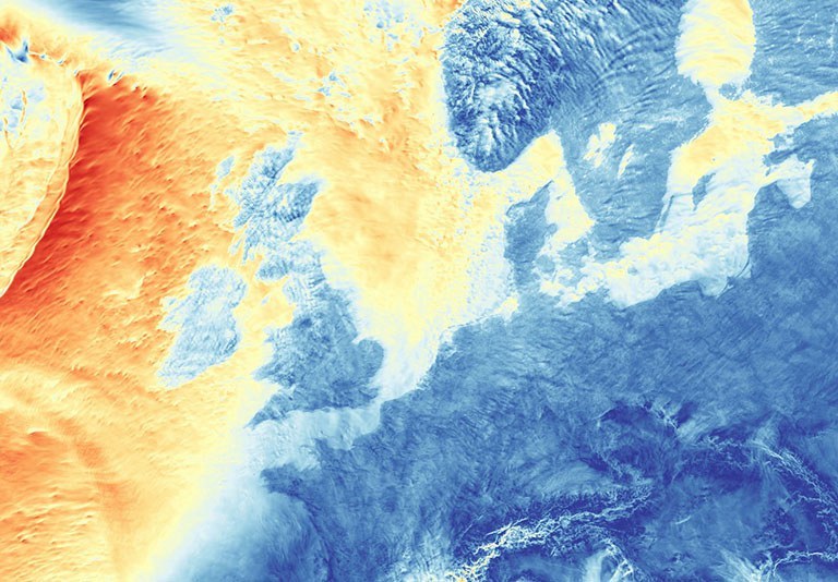
Figure 2: The visualization shows the vorticity in the ocean in different brightnesses for the ice-covered and the ice-free ocean. In addition, a false-color representation of the ICON model topography has been added to the image on the land surfaces. The individual image parts originate from a novel interactive visualization tool, which is being developed at the MPI-für Meteorologie for interactive access to the extremely high-resolution and extensive model data.
Outlook
This new, high-resolution and more physical generation of climate models will address some previously unresolved questions about kilometer-scale processes. Coupled with innovative data processing, this path will lead to new questions and insights in climate research.
The current developments are part of the BMBF-funded project WarmWorld, as well as the EU-funded projects nextGEMS, EERIE and DestinE, and through the latter also contribute to the idea of developing a digital twin of the Earth system.
Contact
Max-Planck-Institut für Meteorologie (MPI-M), Bundesstraße 53, 20146 Hamburg: Daniel Klocke, Angel Peinado, René Redler, Leonidas Linardakis, Luis Kornblueh, Tobias Kölling
Deutsches Klimarechenzentrum (DKRZ), Bundesstraße 45a, 20146 Hamburg: Jan-Frederik Engels