![]() The project aims at a better understanding how the slow feedbacks in the earth system operate and to employ this knowledge for producing improved projections of the future climate. The last glacial cycle is ideally suited to analyse the response of the modelled climate to changes in the orbital forcing and to test the models’ capability to capture the modelled statistical climate variability on timescales up to several thousand years, when processes like ice sheet – climate interactions become dominant.
The project aims at a better understanding how the slow feedbacks in the earth system operate and to employ this knowledge for producing improved projections of the future climate. The last glacial cycle is ideally suited to analyse the response of the modelled climate to changes in the orbital forcing and to test the models’ capability to capture the modelled statistical climate variability on timescales up to several thousand years, when processes like ice sheet – climate interactions become dominant.
Moreover, PalMod intends to identify and quantify interactions between climate change, ice-sheet response (leading to sea-level changes), and biogeochemical cycling, which ultimately determine the earth system’s sensitivity to external forcing.
The project PalMod is envisioned to run over 10 years in three funding cycles. The already completed first Phase focused on the development of coupled climate - ice-sheet models to study the deglaciation phase of the last glacial cycle. The ongoing second phase has started in 2019 and will end in 2022. It adresses the earth system behaviour under different climatic boundary conditions, focusing on three climate periods: Glacial Inception, Marine Isotope Stage 3 and Deglaciation. To achieve this goal, it is first necessary to integrate the physical and the biogeochemical components to develop a fully coupled ESM including ice sheets, and second, to parameterize important key processes such as ice shelf-ocean interactions or weathering. Furthermore, the model development tasks of the project will focus on implementing and optimizing the deloped ESMs with regard to high throughput on current and future computer architectures.
It is planned to study changes in the mean climate and climate variability and to verify the model results by comparison to a compilation of homogenized paleo-climatological and paleo-vegetation data for the last 130,000 years. Finally, at the end of phase II, the development of the fully coupled ESMs will be completed, such that these can be used for transient simulations of the full last glacial cycle planned in phase III.

Figure 1: Structure of PalMod phase II with three working groups connected through cross cutting activities.
Working Groups during the 2nd Phase of PalMod
In its second phase, the project PalMod uses a structure of three working groups (WGs) that are connected through different cross cutting activities (figure 1). WG1 (physical system) and WG2 (biogeochemical system) will closely work together to integrate both systems into a fully coupled ESMs. This will foster the understanding of processes controlling the coupling of biogeochemistry and climate during geological periods and to quantify the feedbacks.
Proxy data are the key to validate the ESMs used in WG1 and 2. Therefore, the aim of WG3 (data synthesis) is to generate a quality-controlled synthesis of quantitative proxy records (data that can be used to indirectly get estimates of the desired quantity) from the marine and terrestrial realms. This synthesis will allow diagnosing individual aspects of the model simulations (ocean circulation, ocean biogeochemistry, hydrological cycle, land cover and vegetation and the pattern of climate variability). In the 2nd phase, the existing efforts in the synthesis of proxy time series will be extended from the last 40,000 years to the entire last glacial-interglacial cycle.
Finally, the cross-cutting activities (CC) create a platform that is dedicated to research and services to support and connect the working groups 1-3. By coordinating and participating in this working group, DKRZ plays an active role in the PalMod project.
Within CC.1 the optimization of the ESMs towards a higher throughput of the fully coupled setup is a crucial task to enable reaching the overarching goal of simulating a complete glacial cycle. Based on the targeted time horizon, a minimum integration rate of 400 simulated years per day is mandatory to run the full transient experiment within one year (wall clock time). One of the three models involved in PalMod is the Max Planck Institute Earth System Model (MPI-ESM). For standalone experiments of the coarse resolution setup (MPI-ESM T31/GR30), the aspired integration rate has already been achieved, but the fully coupled setup for PalMod shows much more complexity as laid-out in Figure 2. Therefore, two main tasks had to be completed during the 1st phase of the project. Most of this work was done in the Ocean Physics Group of the MPI for Meteorology:
- Addition of an Energy Balance Model (EBM), an Ice Sheet Model (PISM) and a three-dimensional Viscoelastic Lithosphere and Mantle Model (VILMA) to MPI-ESM.
- Evaluation of the topography and adaptation of the formerly static MPI-ESM components to topography and bathymetry changes on paleo-timescales [Meccia & Micolajewicz, 2018; Riddick et al., 2018].

Figure 2: Sketch of the fully coupled MPI Earth System Model used in PalMod.
The coupling between MPI-ESM and the other components is based on interleaved simulation steps, where the model can be run in two different configurations:
- Sequential mode, where MPI-ESM simulates the coupled atmosphere-ocean system for 10 years. Then the glacial changes and the earth’s response to them are evaluated. Finally, the topography calculations are done.
- Asynchronous mode, where the ice sheet development is simulated concurrently with the atmosphere-ocean system. This approach introduces a lag error in the physics, however, due to the slowness of the glacial changes the error is small and hence acceptable.
The analysis of coupled simulations with MPI-ESM and PISM has already allowed PalMod scientists to identify a two-stage climate response to Heinrich events. Heinrich events are massive ice sheet collapses (surges) during glacials. Ziemen et al. (2019) identified a first phase, in which the ice input from the surge weakens the ocean circulation and thus cools the North Atlantic. In a second phase, the topography changes in the ice sheet resulting from the loss of ice cause a change in the North Atlantic jet stream and thus prolong the climate response to the surge.
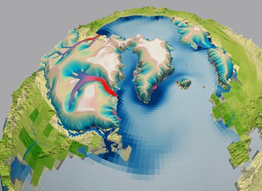
Video 1: A simulation of the last deglaciation in a fully coupled ice sheet – solid earth – climate simulation with PISM, VILMA, and MPI-ESM performed on the DKRZ supercomputer Mistral. Colors on the ice sheet mark ice surface speed. The periodically appearing reddish “river” in the ice Laurentide ice sheet (present-day Canada) marks surges of the ice during so-called Heinrich events, when massive amounts of ice slide into the North Atlantic and form icebergs. The voyage of these icebergs can be seen from their melt water release (shades of blue in the ocean). Isolines mark the response of the solid earth to the ice sheets. Greenish lines mark a rising local relative sea level (mostly due to a depression of the ground), brownish lines mark a lowered relative sea level (a combination of the effect of about 100m of sea level stored in the ice sheets and uplift around the ice sheets caused by mantle material displaced below the ice sheets).
For the ongoing PalMod phase II, it remains to enable the desired integration rate of the fully coupled model and to possibly increase the resolution towards T63 in ECHAM6. Furthermore, the transition from the current to the next generation HPC-system at DKRZ will be supported by working group CC.1.
Data management plan for PalMod
A main focus of DKRZ within CC.2 is the coordination of the Research Data Management (RDM) workflows. Along with a framework of communication between the work packages, the RDM aspects covered in CC.2 involve planning and implementation of data production standards, data exchange, archiving, and sharing among internal as well external project counterparts.
A major aspect is the compilation and maintenance of the PalMod phase II data management plan (DMP). Data workflows for both, climate models as well as proxy data compilations, are collaborated within CC.2 and are defined in the DMP in order to evolve data-related communication. The DMP will be updated continuously over the course of the project timeline, and remains useful to the scientific community after the project has ended. One benefit of a DMP is obviously given by the fact that the total amount of model output is expected to be much larger than the available disk space to the project (table below). Here a DMP can work as a communication tool between the project partners to motivate a more efficient resource usage.
| Project phase | Expected data volume | Data volume "/work" | Data volume "DOKU" | tape archive |
CPU hours |
|
PalMod-II (9 WPs) |
3.8 Petabyte |
1.2 Petabyte (granted) 1 Petabyte (used) |
720 Terabyte (granted) 6 Gibabyte (used) |
1.5 Petabyte (granted) 550 Terabyte (used) |
1.7 Mio. (granted) 960.000 (used) |
Another activitiy of DKRZ within CC.2 is to enable the publication, global dissemination and long-term archival of the most important project outcomes (figure 3). One practical aspect of this work involves the definition of essential variables in order to cut down storage space at DKRZ and to design data standardization procedures.

Figure 3: Handling of the data management related tasks in PalMod phase II by CC.2.
Project Partner
PalMod phase II incorporates 14 national partners from all major climate research institutes and universities as well as the Memorial University of Newfoundland, St. John’s, Canada. The Scientific Advisory Board (SAB) consists of eight international outstanding experts in the field of paleoclimate modelling, biogeochemical research and computational geosciences.
Information on the partners and on the PalMod project: www.palmod.de
Contact
Dr. Kerstin Fieg, Helmholtz Centre for Ocean Research Kiel (GEOMAR): a2ZpZWdAZ2VvbWFyLmRl
Publication
Ziemen, F., Kapsch, M.-L., Klockmann, M., & Mikolajewicz, U. (2019). Heinrich events show two-stage climate response in transient glacial simulations. Climate of the Past, 15, 153-168. doi:10.5194/cp-15-153-2019
Meccia, V. & Mikolajewicz, U. (2018). Interactive ocean bathymetry and coastlines for simulating the last deglaciation with the Max Planck Institute Earth System Model (MPI-ESM-v1.2). Geoscientific Model Development, 11, 4677-4692. doi:10.5194/gmd-11-4677-2018
Riddick, T., Brovkin, V., Hagemann, S. and Mikolajewicz, U. (2018) Dynamic hydrological discharge modelling for coupled climate model simulations of the last glacial cycle: the MPI-DynamicHD model version 3.0. Geoscientific Model Development, 11. pp. 4291-4316. doi:10.5194/gmd-11-4291-2018
Complete list of publications within the project PalMod: www.palmod.de/palmod_publications