Three-month predictions - also called seasonal predictions - give average values for the weather during the next three months. With improved reliability they could provide important data for agriculture and industry.
European winters were previously considered barely predictable; the so-called North Atlantic Oscillation (NAO) was too chaotic. However, its typical combination of Iceland low pressure systems and Azores high pressure systems has a particularly strong influence on the winter in many parts of Europe. Dobrynin and his team have taken advantage of this fact. The NAO works like a switch that influences the path of the air streams over the Atlantic. If you can predict which position the switch is in, you will get indications of the future mean weather in Europe.

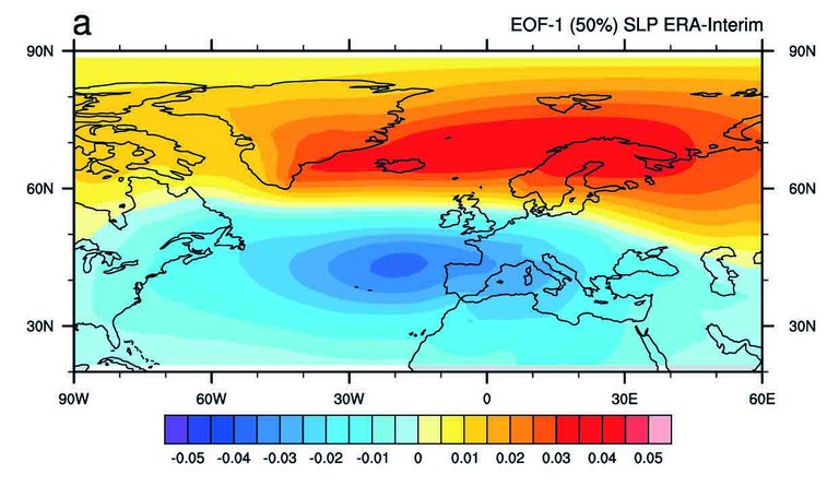
Figure 1: Representation of the mean North Atlantic Oscillation (NAO) during winter - it provides indications of the future average weather in Europe. The strength of the NAO is characterized by the ratio of Iceland low (here red) to Azores high (blue). The greater the pressure difference, the greater the inflow of moist ocean air from the Atlantic to Europe (source: Dobrynin et. al 2018).
Using a new method, Dobrynin can predict the switch positions of the NAO much more accurately: The evaluation of the winters from 2001 to 2017 has shown that the predictions have improved in more than 50 percent of the cases. This is the first time that a seasonal prediction of European weather has a forecast quality similar to that of tropical regions.
"Although there have been going on international and German projects on seasonal predictions for some time now, the results have hardly been better than if we had guessed," says Dobrynin. "Now we reach a very good hit rate for the first time."
To achieve this, the oceanographer includes so-called teleconnections. These are certain regions scattered around the globe that have a clear connection to the average weather of another region of the earth. For example, snow cover in Siberia in October will affect the coming winter in Europe, as will the North Atlantic Ocean or higher levels of air over the Arctic. Teleconnections are difficult to identify and they change over time. But including them in the three-month predictions seems to make those much more accurate, potentially making them a new tool for better predictions around the world.
The computations of the climate model required for the development of the method were carried out at the German Climate Computing Center (DKRZ). Dobrynin used the high-performance computer Mistral and the computations required about 70,000 node hours of computing time. This would equate to 23 hours if you used all nodes of Mistral only for this task. A typical laptop would have taken more than 60 years to complete these computations.
In a European project, Dobrynin will now incorporate the new method into four different prediction systems. This allows the tool to be tested and compared in real time. The first prediction system used is the German Climate Forecast System (GCFS) that is operated by the German Weather Service and that Dobrynin co-developed: A prediction was made for the months January to March 2019. First result: The three winter months in Germany will be on average about one degree warmer than usual. At the end of March we'll know which one was closer: The GCFS forecast without Dobrynin's method yields only a 0.5 degree warmer winter.
Contact:
- Dr. Mikhail Dobrynin, Centrum für Erdsystemforschung und Nachhaltigkeit (CEN), email: bWlraGFpbC5kb2JyeW5pbkB1bmktaGFtYnVyZy5kZQ==, Tel.: +49 40 42838-7750, University of Hamburg
- Stephanie Janssen, Centrum für Erdsystemforschung und Nachhaltigkeit (CEN), Public Relations, email: c3RlcGhhbmllLmphbnNzZW5AdW5pLWhhbWJ1cmcuZGU=, Tel.: +49 40 42838-7596, University of Hamburg
Publications:
Dobrynin M., Domeisen D. I. V., Müller W. A., Bell L., Brune S., Bunzel F., Düsterhus A., Fröhlich K., Pohlmann H., Baehr J. (2018): Improved teleconnection-based dynamical seasonal predictions of boreal winter. Geophysical Research Letters, 43. https://doi.org/10.1002/2018GL077209
Further information of the German Climate Forecast System (GCFS):
- Saisonal predictions by the German Weather Forcast (Deutscher Wetterdienst): https://www.dwd.de/DE/leistungen/jahreszeitenvorhersage/projektbeschreibung.html?nn=612472&lsbId=612150
- Forcasts: https://www.dwd.de/DE/leistungen/jahreszeitenvorhersage/jzvhs_home_node.html
