MPI-ESM1.2
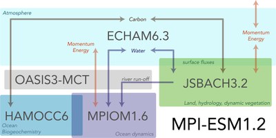
 The earth system model MPI-ESM1.2 is based on the atmosphere model ECHAM6.3, the ocean model MPIOM1.6, and the terrestrial biosphere model JSBACH3.2 as well as the biogeochemistry model HAMOCC6, which simulates biogeochemical processes in the ocean. A separate coupling program (OASIS3-MCT) establishes the link between the different components, in which energy, momentum, water and CO2 are exchanged. JSBACH, however, is directly coupled to the atmosphere, and the ocean biogeochemistry model HAMOCC directly to the physical ocean model.
Compared to MPI-ESM, the Hamburg model for IPCC-AR5, this new model has been improved with regard to the resolution and the representation of various processes. Different spatial model resolutions have been used, depending on the experiments. For the CMIP6 scenario simulations (ScenarioMIP), two different model configurations were used:
MPI-ESM LR: T63L47/GR15L40
- Atmosphere: ECAHM6.3, approximate horizontal resolution of 200 km (1.875 degrees) at 47 layers (up to 0.01 hPa / 80 km in height)
- Land biosphere (interactive vegetation): JSBACH3.2, same horizontal resolution as the atmosphere
- Ocean including biogeochemistry: MPIOM/HAMOCC, horizontal resolution varies from 12 to 150 km at 40 layers
MPI-ESM HR: T127L95/TP04L40
- Atmosphere: ECHAM6.3, approximate horizontal resolution of 100 km (0.9375 degrees) at 95 layers (up to 0.01 hPa / 80 km in height)
- Land biosphere (interactive vegetation): JSBACH3.2,same horizontal resolution as the atmosphere
- Ocean including biogeochemistry: MPIOM/HAMOCC, horizontal resolution varies with an average of 0.4 degrees (40 km) at 40 layers
AWI-CM-1-1
The climate model AWI-CM-1-1 uses ECHAM6.3 as well for simulating the atmosphere, but coupled to the ocean model FESOM developed at AWI. OASIS-MCT is also the coupler used with AWI-CM-1-1.
AWI‐CM‐1‐1‐MR: ECHAM6.3 T127L95 / FESOM
- Atmosphere: The atmosphere model ECHAM6.3 developed at the MPI for Meteorology is used in the same resolution as in MPI-ESM HR; the horizontal resolution is thus approximately 100 km.
- Ocean: The model FESOM2 has an unstructured grid, which allows for representing especially dynamic areas with increased resolution. The resolution varies from 8 to 80 km; the number of grid points is approximately the same as for a regular global grid with a resolution of 1/4 degree.
Further information
Publication on MPI-ESM1.2:
Mauritsen, T., Bader, J., Becker, T., Behrens, J., Bittner, M., Brokopf, R., et al. (2019). Developments in the MPI‐M Earth System Model version 1.2 (MPI‐ESM1.2) and its response to increasing CO2. Journal of Advances in Modeling Earth Systems, 11, 998– 1038. https://doi.org/10.1029/2018MS001400
Publication on AWI-CM-1-1:
, , , , , , et al. (2020). Simulations for CMIP6 with the AWI climate model AWI‐CM‐1‐1. Journal of Advances in Modeling Earth Systems, 12, e2019MS002009. https://doi.org/10.1029/2019MS002009
